Netalzul Mountain
Project Update
High Grade Silver with Additional Au, Cu, Zn, Pb, Mo and W Potential
Netalzul Presents Highly Leveraged, High Value, Geologically Informed Targets Ready for Drill Testing
- Metallogenic Geological Setting, Structurally Controlled High-Grade Ag, Cu, Au Occurrences
- Accessible Location with Services and Infrastructure
Introduction
The Netalzul Mountain Project (“Netalzul”) is one of four projects on Jaxon’s Hazelton Property in the Omenica Mining Division, 57 km (35 miles) north of Smithers, British Columbia. Netalzul is marked by surficial Ag-Au-Cu-Mo-W-Zn-Pb-Sb polymetallic occurrences. After reviewing and modeling key historical prospecting, staking, geological data, and data collected in the 2020 field season, Jaxon believes the mineralization exposed at Netalzul is analogous to the types of mineralization at the Silver Standard mine at East Hazelton and the Huckleberry porphyry mine 100 km south of Smithers. Over the last 70 years, Netalzul Mountain has had an eventful staking and artisanal mining history but to date has not been systematically explored.
Netalzul covers 71.82 km2 of the northeast corner of Hazelton (Figure 1) and consists of 16 claims comprising five previously held claims, five newly optioned claims and six newly acquired claims. Jaxon’s claims were organized by Martial Levasseur, who previously prospected the area independently and with Noranda and Placer Dome. Mr. Levasseur is now an advisor to Jaxon.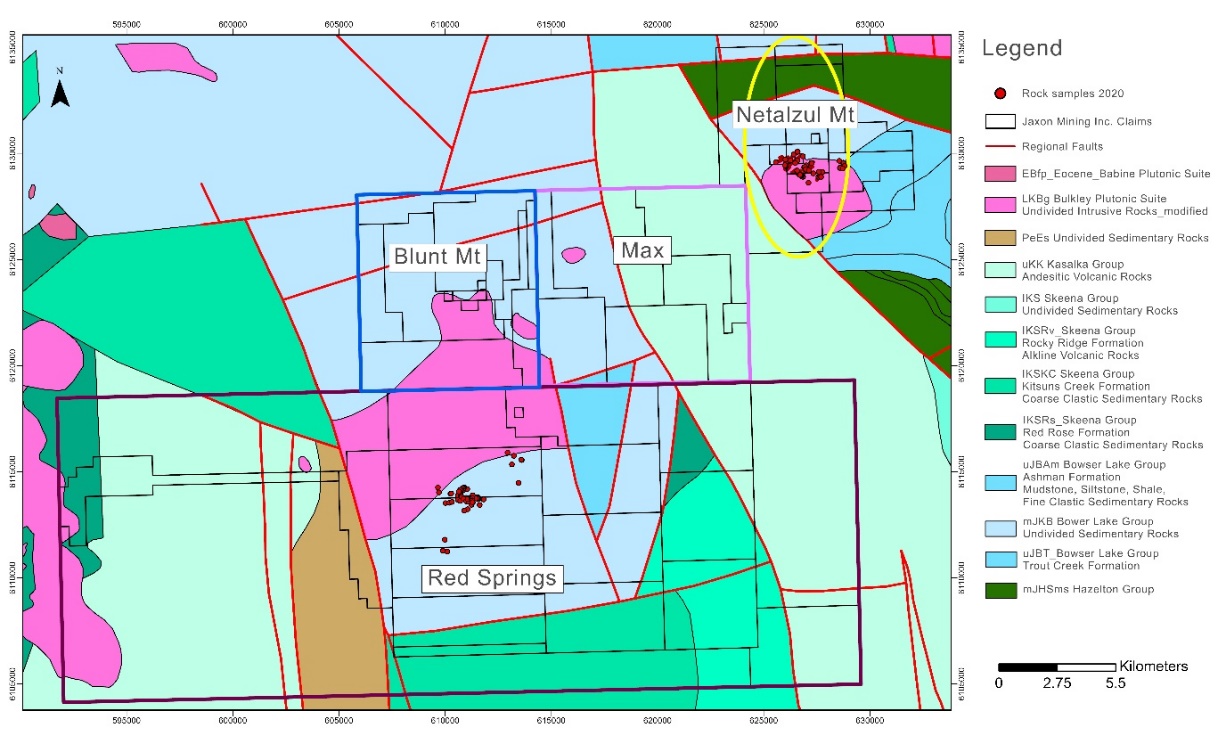
Figure 1. Claim and Geology Map of Hazelton Property

Figure 2. Jaxon's Netalzul Mountain Project Claims Map (in Red)
Exploration History
Sporadic surface exploration work was completed on small parts of Netalzul Mountain by various operators (Table 1, Figure 3). The first documented work was carried out by Twin Peaks Mines Inc., who conducted airborne geophysical work in 1969. From the 1970s to 2010s, several surface outcrops, rocks, floats, tilts and soil sampling programs were conducted. In the early 2010s, Amarc Resources Ltd. staked most areas and conducted geophysical, geochemical and drilling work on the east side of Netalzul Mountain. To date, no drilling or detailed prospecting has been done in the areas Jaxon is now targeting.
Netalzul is marked by strong magnetic anomalies that are indicative of a porphyry system. Five historical mineral showings recorded grades of up to 3150 ppb gold and 2387 g/t silver. Jaxon’s interpretation of the historical geophysical and surface work indicates significant potential for the delineation of a Cu-Mo porphyry system with associated high-grade silver and gold polymetallic deposits.
Table 1. Netalzul Mountain Exploration History
| Year | Owner/Operator | Work done | Assessment Report No. |
|---|---|---|---|
1969 | Twin Peaks Mines Ltd. | Airborne geophysics | 2663 |
1972 | Twin Peaks Mines Ltd. & Selco Mining Corp. Ltd. | Petrographic analysis | 3969 |
1985 | Atna Resources Ltd. Tom Richards | Prospecting, silt sampling | 13924 |
1985 | Atna Resources Ltd. | Geochemical works | 15186 |
2010 | Logan Miller‐Tait | Prospecting and Geochemistry | 32043 |
2012 | Amarc Resources Ltd | Geochemical and Geophysical works on the east of Jaxon’s claims | 33499 |
2013 | Amarc Resources Ltd | 34084 |
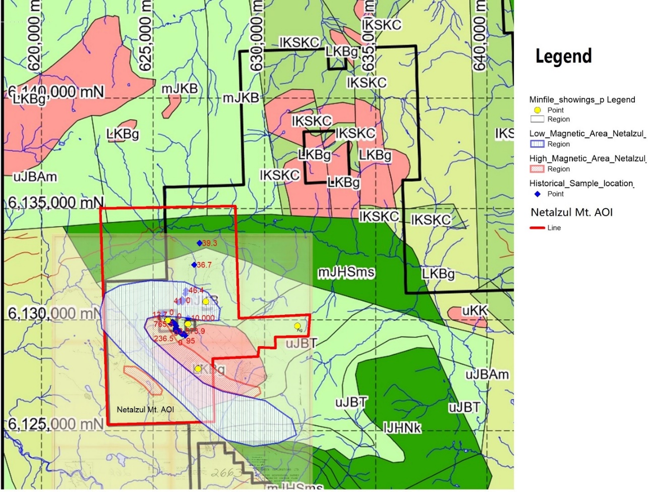
Figure 3. Major Historical Exploration Works at Netalzul Mountain
Property Geology
Netalzul Mountain is situated in the central part of the Intermontane Belt of the Canadian Cordillera, along the Skeena Arch, a northeast-trending tectonic element of Jurassic age. Lower to Middle Jurassic Hazelton Group (lmJHz) comprise the assemblage of marine and non-marine calc-alkaline, island arc volcanic that extend throughout much of central British Columbia. Upper Jurassic and Lower Cretaceous Bowser Lake Group (mJKb) and Skeena Group underlie much of the area near the property. The Skeena Arch defines the southern boundary of Bowser Basin.
The Bowser Lake Group consists of light to dark greyish sandstone, siltstone, conglomerate, shale and coal. Stocks, plugs and dykes of Bulkley intrusive complex (LKBg) and Eocene Babine intrusive are scattered throughout the property, along with associated continental arc volcanic Late Cretaceous Kasalka Group (uKK). There have been historical discoveries of significant porphyry copper deposits in the area, such as the Huckleberry, Big Onion, Morrison, Bell and Granisle porphyries. These are associated with either Late Cretaceous Bulkley Creek intrusions or Eocene Babine Lake intrusions.
Netalzul Mountain is underlain by hornsfelsed siltstone, sandstone, and greywackes of Bowser Lake Group (mJKB and uJBT), and granodiorites of the Bulkley intrusive (LKBg) (Figure 4). Granitic rocks are uniform, even-grained to medium-grained biotite hornblende granodiorite. In general, the unit is coarsely fractured and unaltered. Close fractured zones and shear zones are distributed throughout the intrusive. These shears and dykes trend northeast and dip steeply (Figure 5).

Figure 4. Netalzul Mountain Project Geology Map
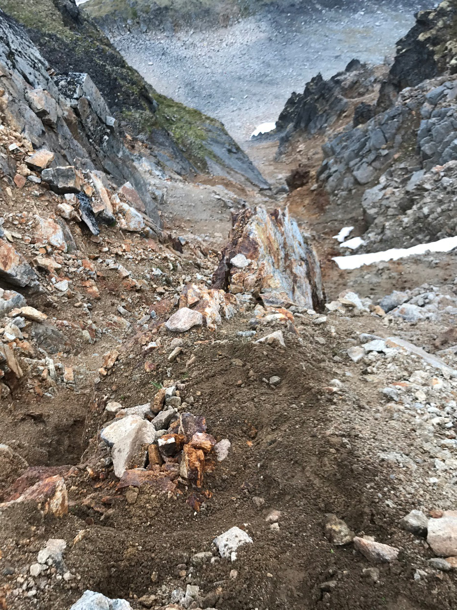
Figure 5. Outcrops of steeply dipping sulfide quartz vein within strong fractured granitic intrusion.
Magnetic Features
In 1969, a mounted helicopter completed an 88-line airborne magnetic and electromagnetic survey of approximately 15 square miles. One magnetic high and two magnetic low areas (Figure 6) with accompanying zones of conductivity are strongly suggestive of the existence of porphyry mineralization in the area (Assessment Report 2663). Figure 6 reveals that the major historical mineral showings are all located in the magnetic transition zone between the magnetic high and magnetic low zones or in the hornfelsed sedimentary rock in the sulfide mineralization distal to the porphyry system.
In 2008, Geoscience BC launched the QUEST-West Project. The program included a 1:500,000 aero-magnetic survey of central B.C., which included the Netalzul Mountain project area (Figure 6).
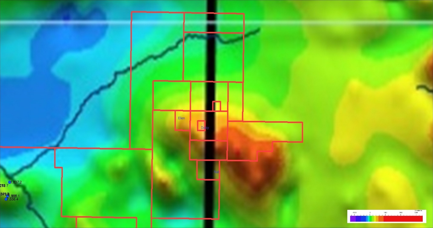
Figure 6. Aero-magnetic Anomaly (RTP) Map of Netalzul Mountain Project Area (After Geoscience BC, 2010)
In 2016, as part of Geoscience BC’s Search Project Phase II, Sander Geophysics Limited (SGL) conducted a fixed-wing high resolution aeromagnetic and gamma-ray survey of central B.C. The processed magnetic data and maps were released in 2017. The surveyed area included only the east part of the Netalzul Mountain project area but with greater accuracy (Figure 7).
In September of 2020, Jaxon commissioned Genesis Aviation to perform advanced LiDar and aeromagnetic surveys over the Netalzul Mountain project area. The survey data will be released once the information has been collected, processed and integrated into Jaxon’s conceptual geological models.
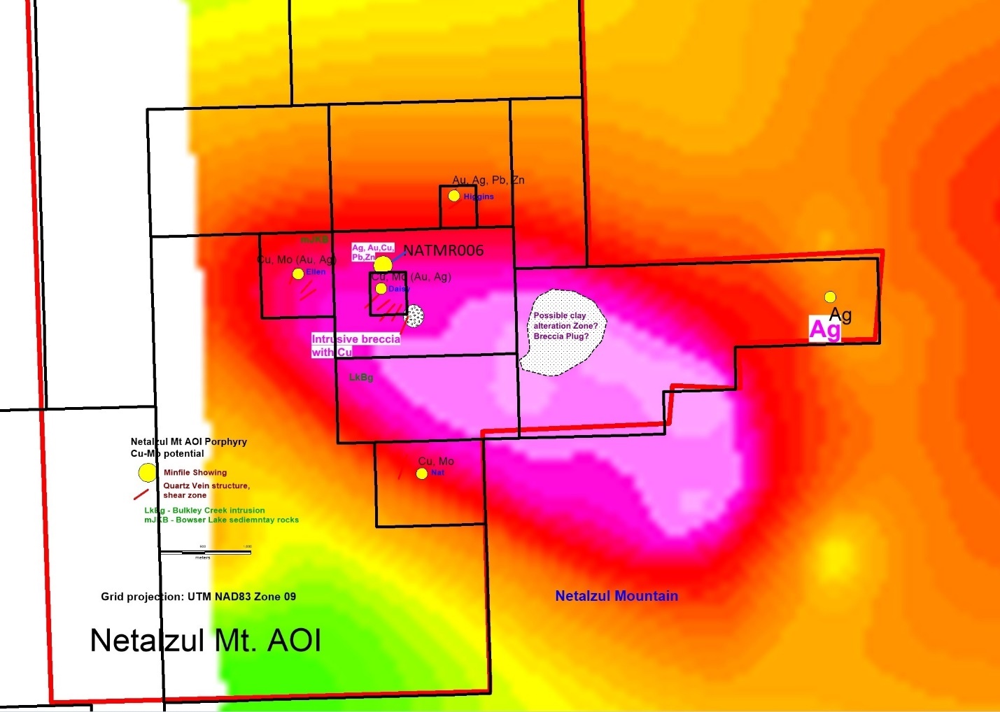
Figure 7. Aero-magnetic Anomaly (RTP) Map, Historical Mineral Showings and Interpreted Porphyry Features at East Part of Netalzul Mountain Project Area (After Geoscience BC, 2017)
Both the 2010 and 2017 magnetic anomaly maps show a strong magnetic high anomaly in the stock of the Bulkley granitic intrusive (LKBg). There are several minor variances of the magnetic anomalies observed in the magnetic high area in both the 2010 and 2017 magnetic RTP maps, which should be investigated further for potential relation to the porphyry system. The magnetic signatures at Netalzul show similar magnetic features to that of the other areas such as Blunt Mountain. The historical mineralization showings and workings are mainly located in the medium magnetic high anomaly area at Netalzul Mountain.
Mineralization
Mineralization at Netalzul Mountain has been identified as polymetallic vein type Ag-Au-Cu and Ag-Pb-Zn-Cu, and porphyry type Cu-Ag-Au mineralization. Polymetallic vein type mineralization occurs in sulphide veins up to 2 metres in width and >1000 metres in length. Sulfide veins contain pyrite, chalcopyrite, tetrahedrite, galena, sphalerite, wurtzite, molybdenite, muscovite and quartz in hornfelsed sediments and granodiorite (Figure 8). The veins observed can occur in both hornfels and granite. Based on the surface prospecting and soil sampling programs conducted August and September of 2020, three large vein zone systems have been defined: the Old Working contact zone (Daisy north), the Adit zone (Daisy south) and the Daisy East zone (Figure 9).
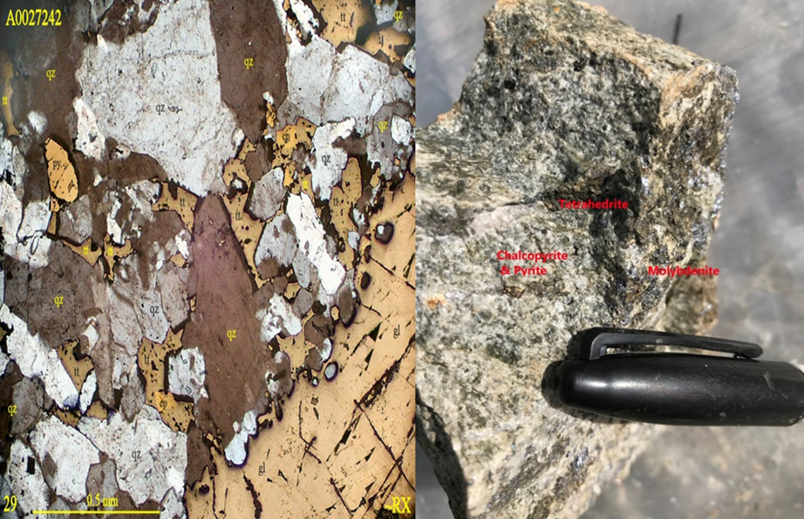
Figure 8. (Left) Thin section from a large sulfide quartz vein >2 metres in width with quartz (qz), galena (gl), chalcopyrite (cp) and tetrahedrite (tt) from Adit 1 area. (Right) High-grade Ag-Zn-Pb-Cu sulfide vein mineralization from artisanal workings area along the contact/fault zone between granite intrusive and hornfels.
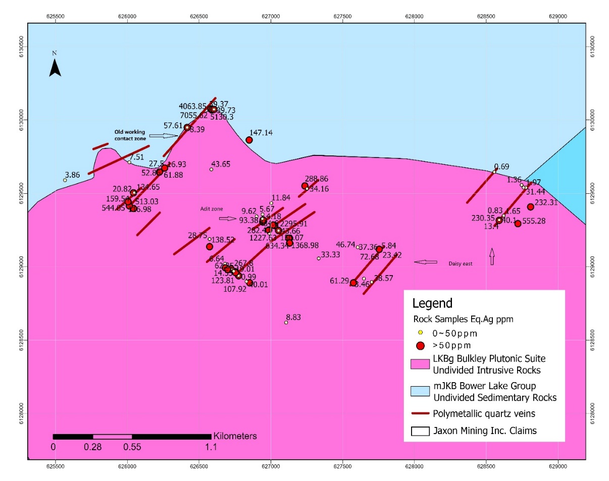
Figure 9. Three quartz veins and silver polymetallic mineralization zones defined at Netalzul Mountain: Old Working contact zone, Adit zone and Daisy East
Adit Zone (Daisy South)
A total of 42 outcrop chip/grab samples have been collected by Jaxon’s field geologists during the 2020 field season from August to October (Table 2 and Figures 9-12).
Highlights of the assay results from the artisanal Adit 1 and 2 areas (Daisy south zone):
- One composite grab sample from adit 1 area contained silver equivalent grades up to 1317 g/t and includes gold grades up to 5.91 g/t, silver grades up to 623 g/t and copper grades up to 3.45% (Figure 10, left and Table 2)
- One 2 metre outcrop chip sample from quartz sulfide vein at adit 1 area contained silver equivalent grades up to 623 g/t and includes gold grades up to 1.59 g/t, silver grades up to 411 g/t and copper grades up to 0.71% (Figure 10, right and Table 2).
- One 5 metre outcrop chip sample from adit 2 area contains silver equivalent grades up to 1073 g/t and includes gold grades up to 2.30 g/t, silver grades up to 620 g/t and copper grades up to 1.17%, lead grades up to 2.74% and antimony grades up to 0.89% (Figure 11 and Table 2)
- Both veins or vein zones range in size from 2 to 5 metres wide and are traceable for up to 50 to 100 metres on the surface. Veins in the granitic rocks occur in association within shear zones trending between 40 and 70 degrees, dipping steeply around 70 degrees west. Based on the soil anomalies and high-grade rock sample assay results (Table 2) at the top of the ridge to the west side of the valley (rock samples A0020733, A0020728, A0020726 and A0020721), both Adit 1 and Adit 2 vein or veins zone extend to the west for at least 600 metres with a 300 metre elevation difference (Figure 12).
Table 2. Significant Assay Results of 42 Rock Samples from Adit Zone (Daisy South Zone)*
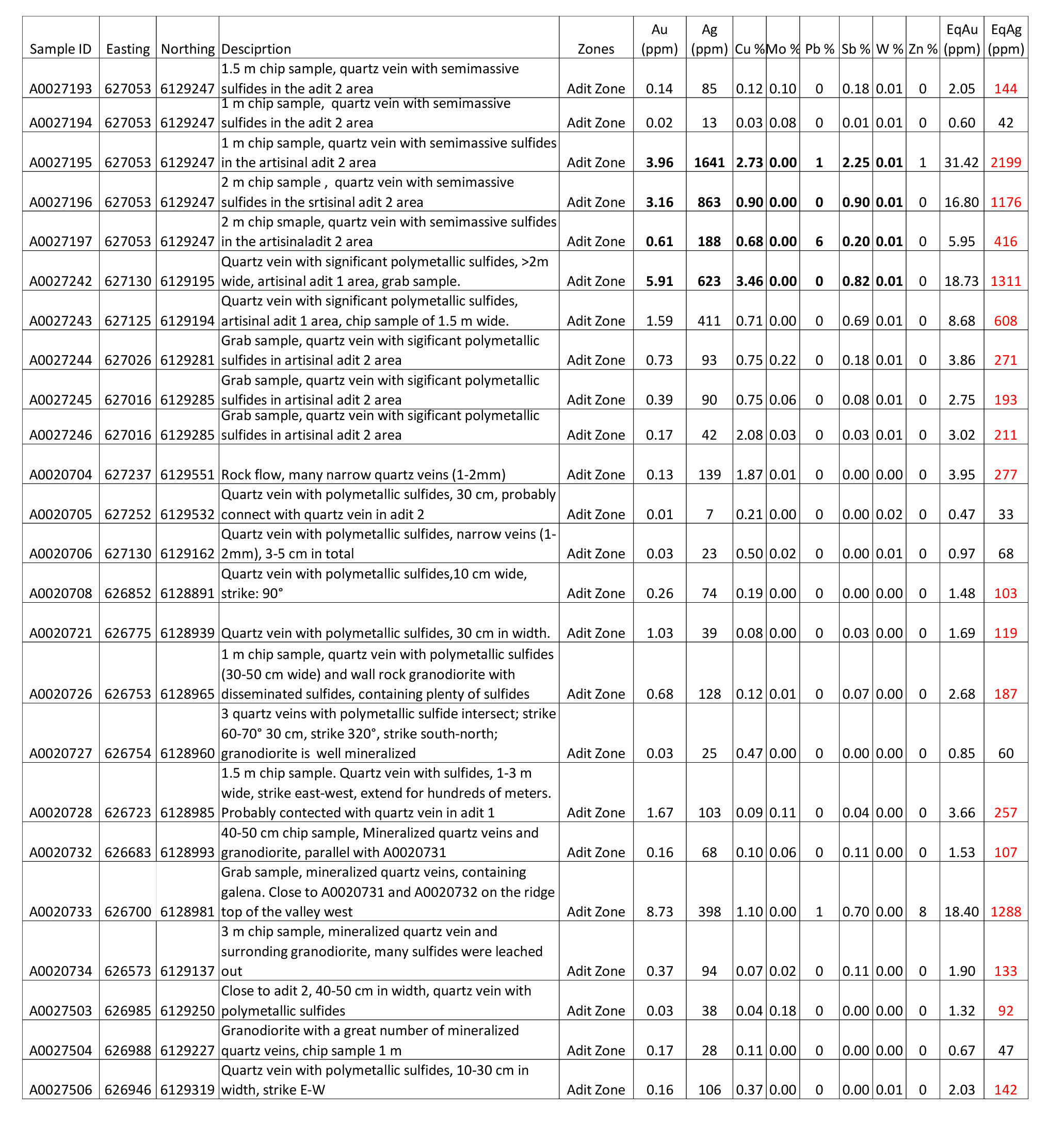
*EqAu grade is calculated based on gold priced at USD$1900/ounce; silver at USD$26/ounce, copper at USD$6000/tonne, molybdenum at USD$24000/tonne, lead and zinc at USD$1800/tonne, antimony at USD$5000/tonne, and tungsten at USD$ 40000/tonne.
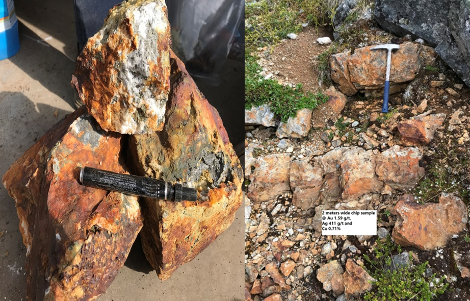
Figure 10. (Left) Sulfide quartz veins from artisanal Adit #1 area with AgEq grades of 1317 g/t. (Right) 2 metre wide sulfide veins from artisanal Adit #1 area with AgEq grades of 623 g/t.
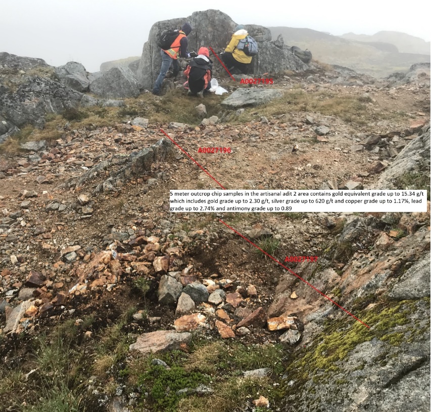
Figure 11. 5 metre wide sulfide quartz veins from artisanal Adit #2 area with AgEq grades of 1074 g/t.

Figure 12. Adit #2 veins are visible westerly from bottom of the valley to the top of the ridge.
Old Working Contact Zone
High-grade silver polymetallic mineralization has been discovered at the third artisanal workings site at Netalzul. A historical high-grade polymetallic sample (NATMR006) had previously been taken from this site and documented in BC Geological Survey Assessment Report #32043 (2010), and reported assay results of >10,000 ppm Cu, >10,000 ppm Pb, >100 ppm Ag, 2597.9 ppb Au and >2000 ppm Sb. Both the current and historical samples were taken from the area of the contact/fault-controlled shear zone between granite and hornfels (Figure 13). Upon discovery in 2020, the field team re-mapped and re-sampled the area around the artisanal workings and traced its extension along the contact zone, sampling a total of 23 rock chip/grab samples. The assay results are listed in Table 3 below.
The 2020 assay results confirm the presence of the high-grade silver polymetallic mineralization along this contact zone as previously reported. The mineralization is strongly structurally controlled by either a large contact or fault shear zone between the Jurassic Bowser Lake hornfels and the Bulkley granite intrusive or within the Bulkley granite intrusive itself (Figure 9).
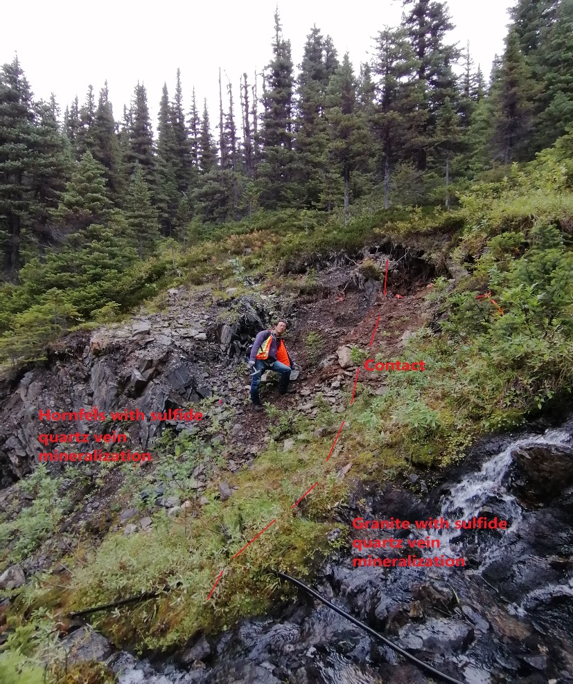
Figure 13. Artisanal workings site, fault/shear-controlled contact zone between granite and hornfels.
Table 3. Significant Assay Results of 23 Rock Samples from Old Working Contact Zone*
| Sample ID | Easting | Northing | Descriptions | Au | Ag | Cu % | Mo % | Pb % | Sb % | W % | Zn % | EqAu | EqAg |
|---|---|---|---|---|---|---|---|---|---|---|---|---|---|
A0027240 | 626043 | 6129397 | Quartz sulfide vein along fracture zone in granite, 1 m wide; locally, >100 m fracture zone, multiple quartz veins in the fracture zone | 0.14 | 5 | 0.00 | 0.33 | 0 | 0.01 | 0.84 | 0 | 7.02 | 491 |
A0027241 | 626585 | 6129663 | Quartz vein in a fracture zone > 10m in granite, containing some sulfides | 0.03 | 27 | 0.01 | 0.01 | 0 | 0.01 | 0.02 | 0 | 0.60 | 42 |
A0027252 | 626014 | 6129415 | quartz vein with semi-massive sulfides | 0.05 | 2 | 0.00 | 0.18 | 0 | 0.01 | 0.21 | 0 | 2.18 | 153 |
A0020736 | 626849 | 6129864 | 30 cm quartz vein with polymetallic sulfides | 0.08 | 81 | 0.74 | 0.02 | 0 | 0.00 | 0.00 | 0 | 2.01 | 141 |
A0020737 | 626581 | 6130075 | Historical mining site, dumped ore pile | 0.45 | 5301 | 3.35 | 0.00 | 24 | 2.32 | 0.01 | 38 | 96.55 | 6759 |
A0020738 | 626581 | 6130075 | Historical mining site, dumped ore pile | 0.19 | 2573 | 1.51 | 0.00 | 29 | 1.05 | 0.01 | 31 | 55.61 | 3893 |
A0020739 | 626590 | 6130068 | Grab sample, rock flow, granodiorite with disseminated sulfides, close to the ore pile | 0.01 | 28 | 0.03 | 0.00 | 0 | 0.01 | 0.07 | 0 | 1.06 | 74 |
A0020740 | 626591 | 6130072 | Outcrop, intensive quartz veins, 1.5 m chip sample within hornfel with disseminated sulfides, galena+ chalcopyrite+ pyrite, | 0.48 | 4577 | 3.04 | 0.00 | 3 | 2.08 | 0.01 | 5 | 70.20 | 4914 |
A0020741 | 626591 | 6130072 | 1 m chip sample, hornfel with minor disseminated sulfides | 0.00 | 22 | 0.03 | 0.00 | 0 | 0.01 | 0.00 | 0 | 0.36 | 26 |
A0020742 | 626591 | 6130072 | 2 m chip sample, hornfel with minor disseminated sulfides | 0.02 | 6 | 0.04 | 0.00 | 0 | 0.00 | 0.00 | 0 | 0.16 | 11 |
A0020743 | 626603 | 6130072 | 3 m chip sample, hornfel with minor disseminated sulfides | 0.11 | 3 | 0.04 | 0.00 | 0 | 0.00 | 0.05 | 0 | 0.54 | 38 |
A0020744 | 626603 | 6130072 | Contact zone, 0.5 m chip sample, shear zone, containing Wurtzite and galena. Strike 70°. | 0.14 | 26 | 0.26 | 0.01 | 0 | 0.01 | 0.01 | 1 | 1.13 | 79 |
A0020745 | 626603 | 6130072 | Granodiorite with disseminated sulfides, 1 m chip sample | 0.02 | 8 | 0.15 | 0.08 | 0 | 0.00 | 0.00 | 0 | 0.58 | 41 |
A0020746 | 626603 | 6130072 | Granodiorite with disseminated sulfides, 2 m chip sample | 0.00 | 2 | 0.04 | 0.12 | 0 | 0.00 | 0.00 | 0 | 0.54 | 38 |
A0020747 | 626603 | 6130072 | Granodiorite with disseminated sulfides, 2 m chip sample | 0.03 | 5 | 0.10 | 0.02 | 0 | 0.00 | 0.00 | 0 | 0.28 | 19 |
A0020748 | 626224 | 6129646 | Quartz vein with polymetallic sulfides, but vuggy quartz, because many sulfides were leached out. | 0.15 | 44 | 0.04 | 0.00 | 0 | 0.03 | 0.00 | 0 | 0.85 | 59 |
A0020749 | 626945 | 6129312 | Quartz vein with polymetallic sulfides. Sub outcrop | 0.74 | 128 | 1.29 | 0.00 | 0 | 0.38 | 0.00 | 0 | 4.11 | 287 |
A0020750 | 626943 | 6129306 | Quartz vein with polymetallic sulfides. Sub outcrop | 0.02 | 6 | 0.07 | 0.28 | 0 | 0.00 | 0.00 | 0 | 1.28 | 89 |
A0027510 | 626260 | 6129673 | same location with A0027251, but 251 is vuggy quartz (sulfides were leached out), 510 is quartz vein with sulfide | 0.01 | 7 | 0.06 | 0.04 | 0 | 0.00 | 0.06 | 0 | 0.72 | 51 |
A0027511 | 626043 | 6129504 | Granite with disseminated sulfides, including malachite. Strong oxidized zone, yellow-brown. 3-10 M wide, close to a fracture zone | 0.01 | 8 | 0.27 | 0.00 | 0 | 0.00 | 0.22 | 0 | 1.84 | 129 |
A0027512 | 626048 | 6129505 | Mineralized granite. Composite sample, 4 m | 0.01 | 7 | 0.15 | 0.00 | 0 | 0.00 | 0.00 | 0 | 0.28 | 20 |
A0027513 | 626006 | 6129443 | 1 m mineralized sulfide quartz vein within granite | 2.71 | 311 | 0.29 | 0.00 | 0 | 0.14 | 0.00 | 0 | 7.44 | 521 |
A0027516 | 626005 | 6129443 | Next to 513, mineralized quartz vein and granite, including galena, cpy and moly?. The quartz vein is 4 m in width. Along a fracture zone, strike 60° | 0.19 | 79 | 0.12 | 0.00 | 0 | 0.08 | 0.00 | 0 | 1.60 | 112 |
* EqAu grade is calculated based on gold priced at USD$1900/ounce; silver at USD$26/ounce, copper at USD$6000/tonne, molybdenum at USD$24000/tonne, lead and zinc at USD$1800/tonne, antimony at USD$5000/tonne, and tungsten at USD$ 40000/tonne.
Highlights from the August to September 2020 assay results of the 23 samples from the Old Working contact zone:
- Silver grades from grab samples (10-20 cm polymetallic veins, Figure 14) at the artisanal workings area are up to 5301 g/t with zinc grades up to 37.85%, lead grades up to 24.28%, copper grades up to 3.35 %, and antimony grades up to 2.32% (Table 3, A0020737).
- One 1.5 metre chip sample within the artisanal workings area assayed 4577 g/t silver, 3.04 % copper, 4.52% zinc, 3.40 % lead and 2.08% antimony (Figure 15, Table 3, A0020740).
- The mineralization zone is more than 12 metres wide (not true width) at the artisanal workings site with average gold equivalent grades up to 9.12 g/t or silver equivalent grades up to 638 g/t. Sulfides mineralization in the hornfels within the contact shear zone extends up to seven metres and the mineralization in the granite is up to 5 metres from the contact (Figure 15).
- The shear/fault contact mineralization zone is up to 1000 metres long (Figure 9) along either the contact between hornfels and granite or within granite only. The silver equivalent grades of rock samples in the hornfels and granite along the contact zone west extension are up to 521 g/t (Rock sample A0027513, Figure 16).

Figure 14. Polymetallic vein grab sample from Old Working contact zone, Netalzul Mountain
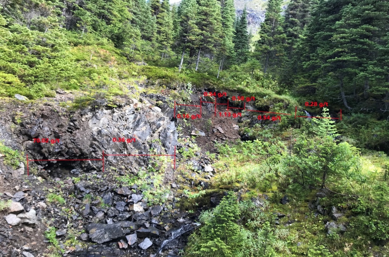
Figure 15. Chip sample with EqAu grades at artisanal workings site within the Old Working Contact Zone, Netalzul Mountain
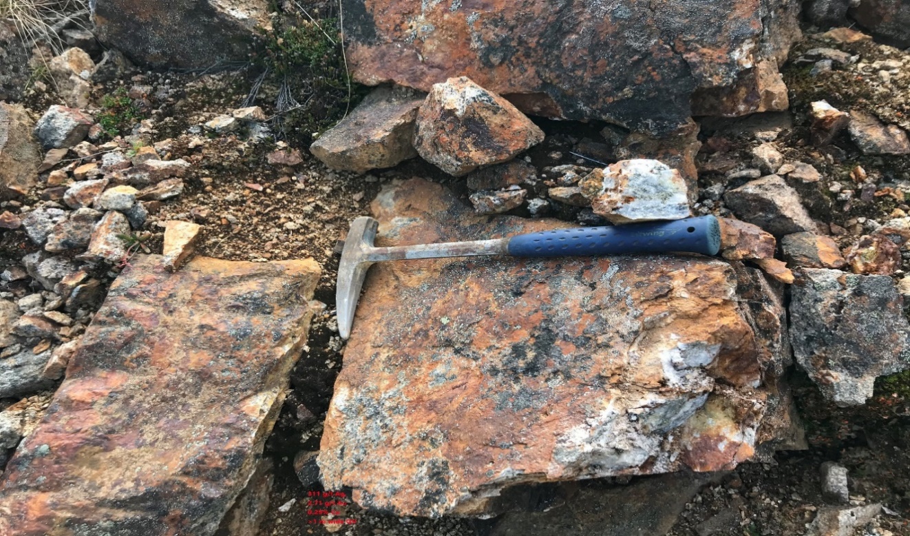
Figure 16. >1 metre thick sulfide quartz vein within the granite at the extension of Old Working contact zone with 311 g/t Ag, 2.17 g/t Au and 0.29% Cu.
Daisy East Zone
The porphyry type Cu-Ag-Au-Mo mineralization at Daisy East is hosted in the granite to quartz monzonite plug of the Late Cretaceous Bulkley intrusions. This porphyry type mineralization is observed at the Ellen and Daisy claims and at the Nat claim, where the mineralization occurs as mainly fracture/vein types with some disseminated chalcopyrite, pyrite and molybdenite in quartz veins, and in the fractures in the granodiorite and hornfels along the contact zone.
A field prospecting program was conducted at Daisy in the 2020 field season: 18 outcrop chip/grab samples were collected (Figures 17-19). Assay and sample details are listed in Table 4.
Rock Sample Assay Highlights from Daisy East Zone
- A >1000 metre long and >1 metre wide large quartz vein Cu-Ag-Ag mineralization zone has been discovered at the Daisy claim east area on the Netalzul mountain-top glacial area (Figures 9, 17).
- Quartz vein chip sample (A0027521) from the top of Netalzul contains up to 2% copper and 75 g/t silver (Figure 17).
- Two grab samples (A0027526, A0027527) from the same area contain up to 221 g/t and 523 g/t silver equivalent, respectively (Table 4).
- One >3 metre chip sample from the west extension (Figure 18) contains up to 54 g/t silver equivalent.
- Locally, malachite, azurite, chalcopyrite and pyrite can be seen in the floats and outcrops in the granite at the Daisy East zone (Figure 19).
The developed quartz vein type Cu-Au-Ag mineralization is overprinted along the fault/shear within the granite, interpreted with the potential to host the porphyry type Cu-Au-Ag-Mo mineralization along the magnetic high belt that extends across the Netalzul Mountain target area.
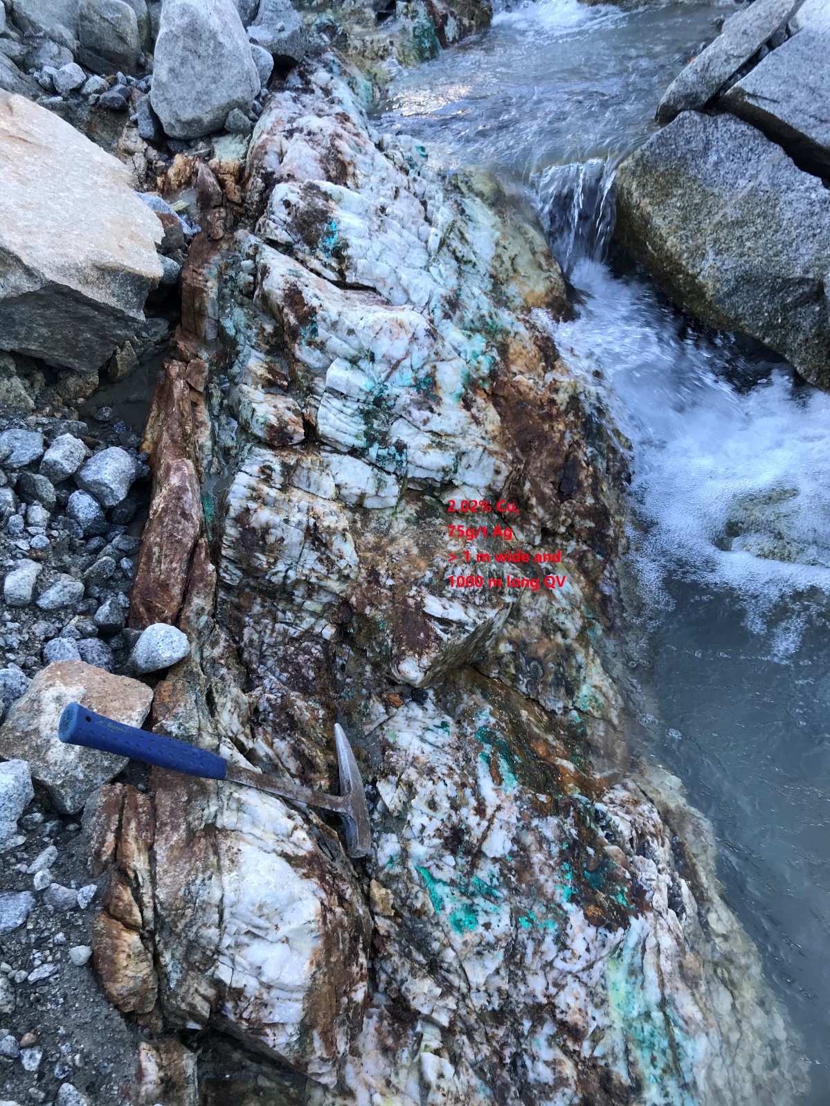
Figure 17. Large sulfide quartz veins within the granite intrusive at Daisy East zone east; one metre chip sample at EqAg 215 g/t.
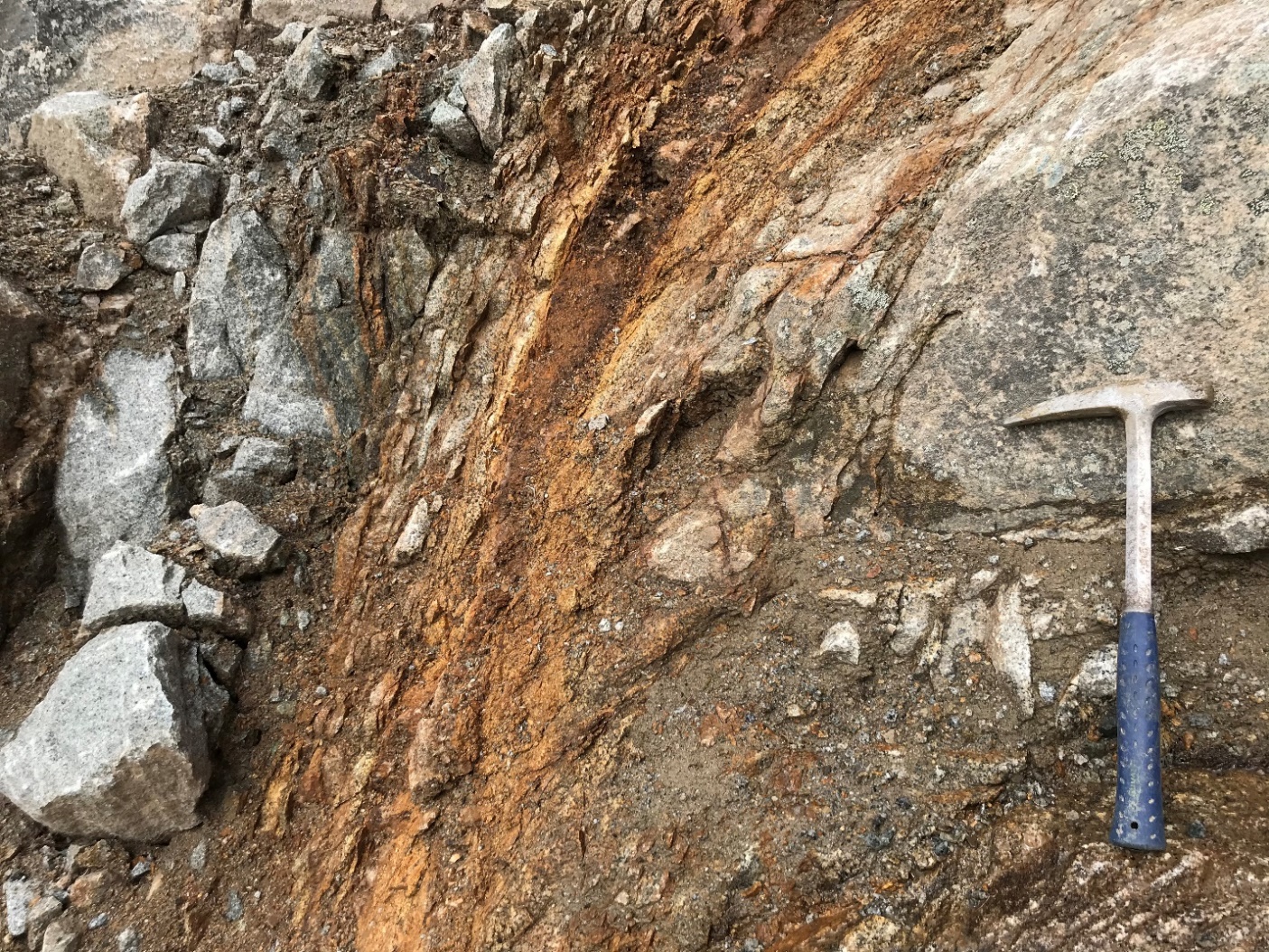
Figure 18. Multiple sulfide quartz veins in a shear zone within the granite intrusive at Daisy East zone west; three metre chip sample at EqAg 54 g/t.
Figure 19. Malachite and chalcopyrite in granite at Daisy East zone east.
Table 4. Assay results from 18 rock samples from Daisy East Zone at Netalzul
Sample ID | Easting | Northing | Description | Au | Ag | Cu % | Mo % | EqAu | EqAg |
|---|---|---|---|---|---|---|---|---|---|
A0020709 | 626830 | 6128900 | Quartz vein with polymetallic sulfide, 1-1.5m, strike 60° | 0.03 | 30 | 0.10 | 0.00 | 0.54 | 38 |
A0020710 | 627575 | 6128891 | narrow quartz veins (1-2mm) with polymetallic sulfides in granodiorite, 20 cm in total, containing malachite, azurite, and covellite | 0.00 | 1 | 0.82 | 0.00 | 0.82 | 57 |
A0020711 | 627648 | 6128919 | Rock flow, many narrow quartz veins (1-2mm) with polymetallic sulfides, 10 cm wide in total, in granodiorite | 0.00 | 0 | 0.03 | 0.00 | 0.04 | 3 |
A0020712 | 627702 | 6128896 | Two wide quartz vein with polymetallic sulfide, mineralized zone is 30 cm in width | 0.03 | 31 | 0.04 | 0.00 | 0.50 | 35 |
A0020714 | 627762 | 6129108 | Granodiorite, hanging wall of a quartz vein with polymetallic sulfide | 0.00 | 1 | 0.06 | 0.00 | 0.08 | 5 |
A0020715 | 627762 | 6129108 | Quartz vein with polymetallic sulfide, should be the same vein with A0020712 | 0.03 | 14 | 0.05 | 0.00 | 0.28 | 20 |
A0020716 | 627762 | 6129108 | Granodiorite, footwall of a quartz vein with polymetallic sulfide | 0.04 | 17 | 0.20 | 0.00 | 0.47 | 33 |
A0020717 | 627754 | 6129119 | Quartz vein with polymetallic sulfides, containing malachite and azurite, in a shear zone, 3 m in width, | 0.07 | 30 | 0.15 | 0.04 | 0.77 | 54 |
A0020718 | 627605 | 6129133 | Rock flow, 3 narrow malachite veinlets in granodiorite | 0.00 | 3 | 0.60 | 0.00 | 0.63 | 44 |
A0027520 | 628587 | 6129315 | Mineralized granite. Wall rock of a quartz vein with sulfides (cpy and malachite) | 0.00 | 0 | 0.17 | 0.00 | 0.17 | 12 |
A0027521 | 628590 | 6129316 | Quartz vein with sulfides, including malachite. 1-2 m in width | 0.07 | 75 | 2.00 | 0.00 | 3.07 | 215 |
A0027522 | 628590 | 6129319 | Mineralized granite. Wall rock of a quartz vein with sulfides (cpy and malachite) | 0.01 | 31 | 0.10 | 0.00 | 0.53 | 37 |
A0027523 | 628621 | 6129348 | mineralized quartz veins in granite | 0.00 | 0 | 0.00 | 0.00 | 0.01 | 1 |
A0027524 | 628621 | 6129348 | mineralized quartz veins in granite | 0.00 | 0 | 0.02 | 0.00 | 0.02 | 1 |
A0027525 | 628760 | 6129540 | Hornfels with QV and Molybdenite, grab sample | 0.00 | 1 | 0.01 | 0.10 | 0.42 | 29 |
A0027526 | 628809 | 6129408 | granite with QV, chip sample on the outcrop | 0.15 | 103 | 1.55 | 0.02 | 3.15 | 221 |
A0027527 | 628720 | 6129294 | granite with QV, chip sample on the outcrop | 1.21 | 361 | 1.36 | 0.01 | 7.53 | 527 |
2020 Soil Sampling Program at Netalzul
Three strong copper/zinc/lead/molybdenum/arsenic anomalies have been defined at Netalzul Mountain based on the soil sampling and geochemistry study program completed September 30, 2020 (Figures 20-24).
The soil geochemistry sampling program covered (+/-) 2 km2, encompassing the Daisy and Ellen claims and their surrounding areas.The soil samples are now being analyzed and assayed for Au/Ag and other minerals.
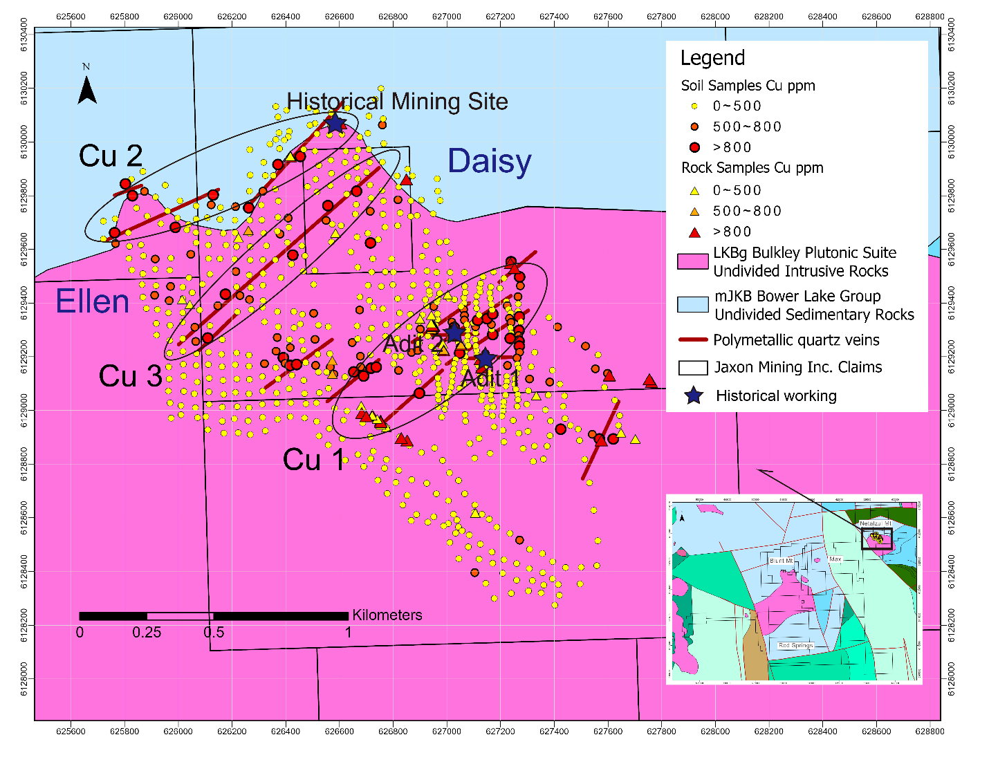
Figure 20. Cu in Soil Anomalies at Netalzul Mountain, Hazelton Property
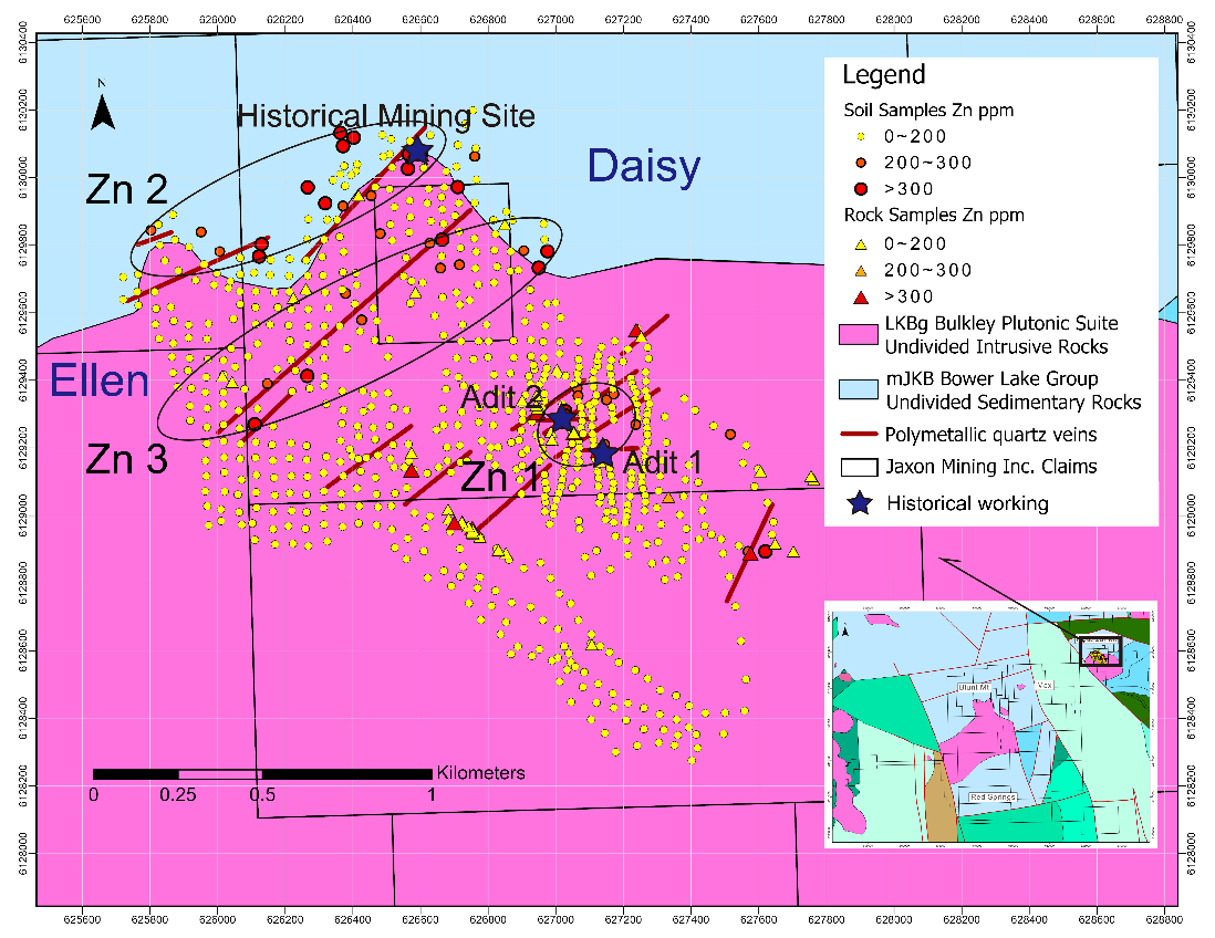
Figure 21. Zn in Soil Anomalies at Netalzul Mountain, Hazelton Property
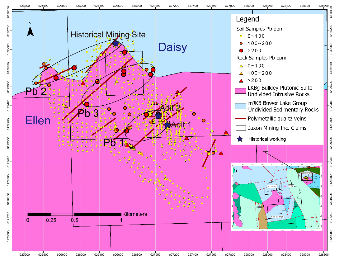
Figure 22. Pb in Soil Anomalies at Netalzul Mountain, Hazelton Property
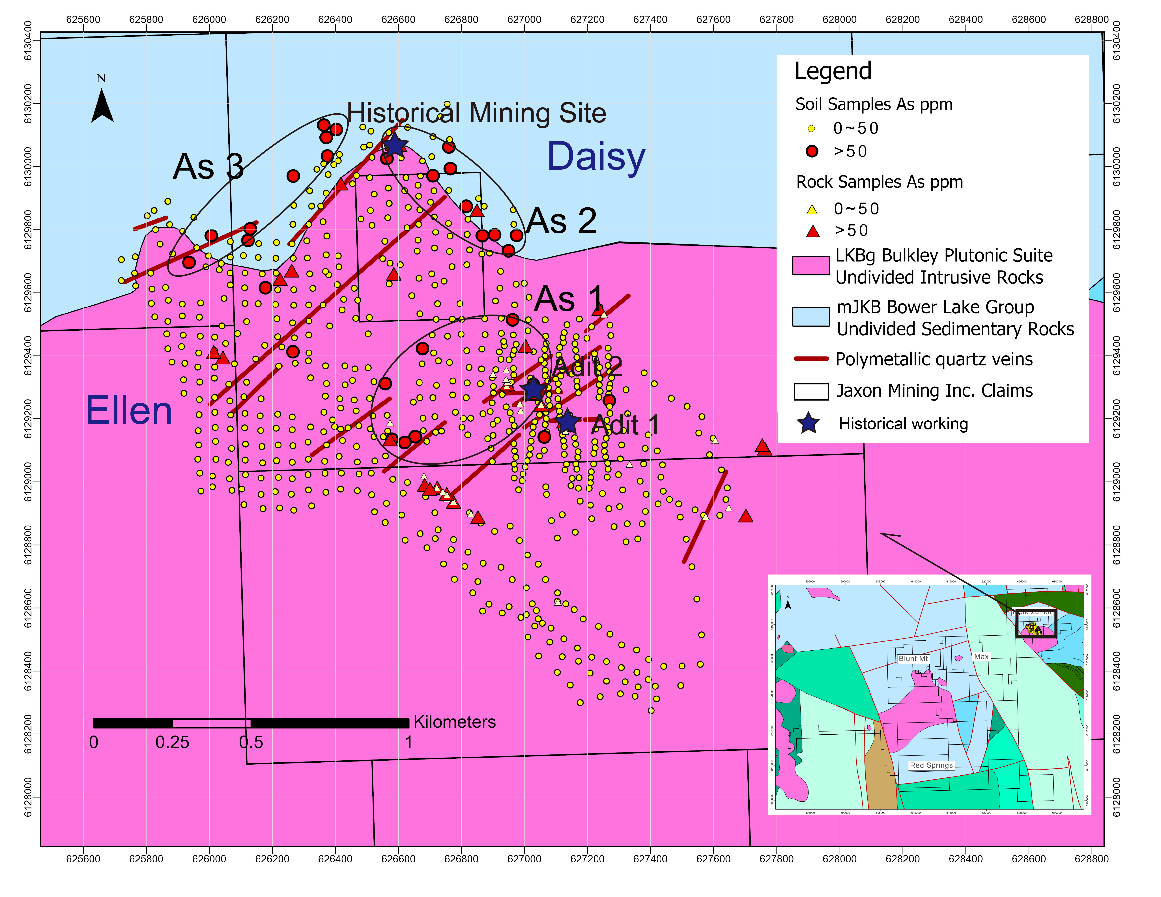
Figure 23. As in Soil Anomalies at Netalzul Mountain, Hazelton Property
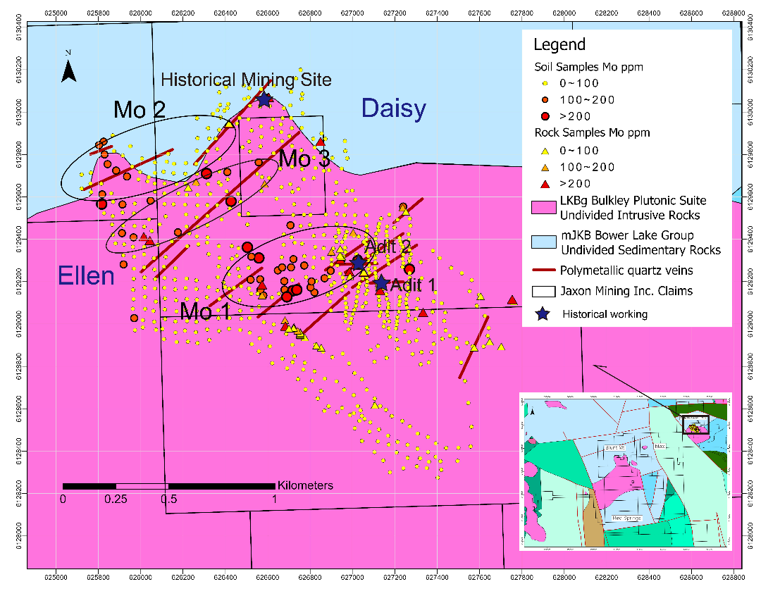
Figure 24. Mo in Soil Anomalies at Netalzul Mountain, Hazelton Property
XRF Analysis of Soil Sampling (Geochemistry Program)
- 50 m x 50 m grid, locally 25 m x 25 m at the Daisy south zone (artisanal workings area), 683 soil samples were taken across the proposed sample stations.
- Cu, Pb, Zn, Mo and As values in soil analyzed using XRF.
- Cu, Pb, Zn, Mo and As anomaly maps created based on XRF analysis results.
- Preliminary results show three strong Cu in soil anomalies (> 500 ppm), three Pb anomalies (>300 ppm), three Zn anomalies (>200 ppm), three Mo anomalies (> 100 ppm), and three As anomalies (> 50 ppm) (Figures 20-24). The team also collected high-grade rock outcrop samples with Cu grades up to 3.35%, Zn grades up to 37.85% and lead grades up to 29.18% (https://bit.ly/30FPu79 and https://bit.ly/30DtkCL) within the same areas. These anomalies indicate three large, high-grade polymetallic mineralized zones, all in close proximity to one another.
- When projected on a plan map, the Cu, Pb, Zn and Mo geochemical and rock sampling anomalies occupy a common area where the As#1 anomaly converges with the Cu#1 anomaly.
- The high-grade rock samples were collected from the area covered by the Cu#1/Zn#1/Pb#1/Mo#1 and Cu#2/Zn#2/Pb#2/Mo#2 anomalies (https://bit.ly/30FPu79 and https://bit.ly/30DtkCL). Additional surface prospecting, sampling and mapping work will be conducted around the Cu#3/Zn#3/Pb#3/Mo#3 anomalies before drilling, now planned for the 2021 work season.
- Plan projections show that the As#2 and As#3 anomalies are also in close proximity to one another and are distributed along the contact zone between granite intrusive and hornfels, partially overlapping the Cu#2, Zn#2, Pb#2 and Mo#2 anomalies. These anomalies overprint the areas where the additional high-grade rock samples were taken. The rock samples collected from the areas overprinted by the geochemical anomalies returned assays with silver grades of up to 5300 g/t (https://bit.ly/30FPu79 and https://bit.ly/30DtkCL). These results indicate further potential for the existence of additional high-grade Ag, Cu and other mineralization at depth along the >1000 metre visible extent of the contact zone.
2021 Netalzul Drill Program
Phase 1 – 2021 (Figure 25)
- 12 holes totaling 3500-4000 metres
- Three holes at Adit 1 zone, 1000 metres targeting >2 metre wide high-grade sulfide quartz veins
- Five holes at Adit 2 zone, 1200-1500 metres targeting up to 5 metre wide multiple quartz veins zone and other two narrow (1 metre) veins (50 metres apart each)
- Four holes at Old Working contact zone (NATMR006), 1000-1300 metres targeting up to 12 metres contact/fault shear mineralization zone
- Budget ~$2.5M CAD
Figure 25. 2021 Phase 1 Drilling Program at Netalzul Mountain
Phase 2 – Dates TBD (Figure 26)
- 19 holes totaling 6000 metres
- Two holes at Adit 1 zone, 800 metres targeting >2 metre wide high-grade sulfide quartz veins
- Four holes at Adit 2 zone, 1200-1500 metres targeting up to 5 metre wide multiple quartz veins zone and other two narrow (1 metre) veins (50 metres apart each)
- Six holes at Old Working contact zone (NATMR006), 1300 metres targeting up to 12 metre contact/fault shear mineralization zone
- Seven holes at Daisy East zone, 2500 metres targeting multiple quartz veins and fracture-controlled mineralization in the granite
- Budget ~$3.5M CAD
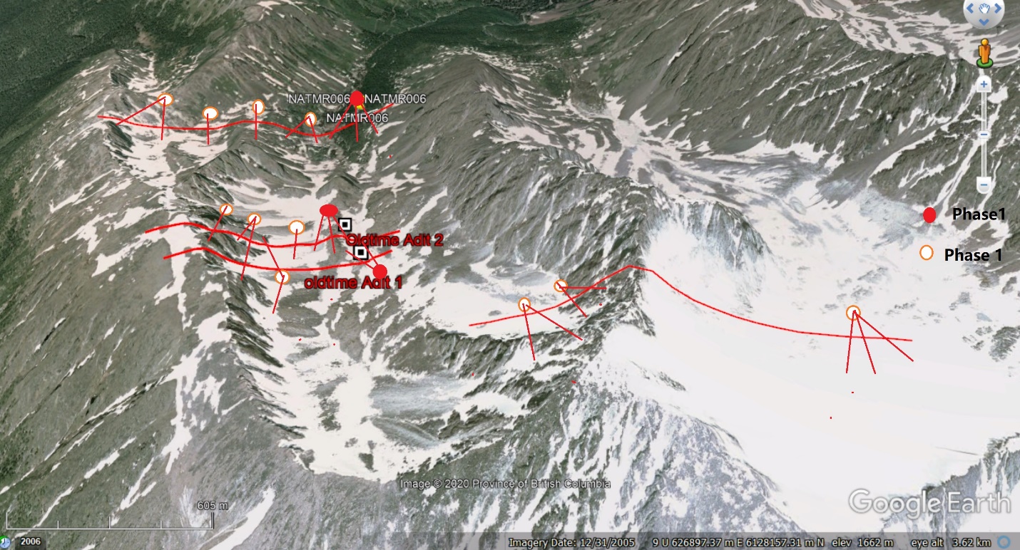
Figure 26. Phase 2 Drilling Program at Netalzul Mountain
Conclusion
The Netalzul Mountain project has multiple showings of high-grade Au, Cu, Ag, Pb, Zn vein type polymetallic mineralization with significant showings at three artisanal adits. Large veins have been observed, with 2 metre plus widths, composed of quartz and sulfide filling in shear and fracture zones. The veins occur in hornfels altered Bowser Lake Group siltstone sandstone and Bulkley intrusive granodiorite. Locally sheeted quartz veining has also been observed in the contact zone of Bulkley intrusion and quartz monzonite plug at the Ellen and Daisy claims. The quartz veins are found in fractures at the shear zone around the artisanal adits. Samples from these areas returned values up to 1640 g/t Ag, 5.9 g/t Au, 3.45% Cu and 6% Pb. A 1.5 metre wide chip sample from the Old Working contact zone returned up to 5000 g/t Ag, 10% Zn + Pb, 3.5% Cu and 2% Sb.
The most interesting results come from sample A0027237 which assayed 5301 g/t silver, 37.85% zinc, 24.28% lead, 3.35 % copper and 2.32% antimony (Table 2, A0020737). These results came from a fault/fracture-controlled shear zone along the contact between granite and hornfels near the north boundary of the Daisy claim. These mineralized veins, fracture and shear zones mostly trend northeast, dipping to the east (some to the west) at steepening angles.
The 2020 surface program focused on mapping and taking rock samples from the sites with visible sulphides and quartz veining. This work confirmed and added to the historic discoveries of anomalous Ag-Cu-Au-Mo values at Daisy. The conceptual geological modeling, with the information from the rock and soil samples, indicate that a deeper porphyry system generated the events at the Daisy East zone, producing the distal silver-copper-gold-lead and zinc values in polymetallic quartz vein mineralization on surface. Additional geophysical surveys have been commissioned and are now underway, to be concluded in October of 2020, weather permitting. The results will provide drill target vectoring information, to map with more precision the porphyry and other structural features controlling the mineralization at depth.
Netalzul Mountain exhibits extensive surface expressions of mineralization generated by fluids from the multiple thermal events that have overprinted the large, rich, polymetallic Cu/Ag/Au porphyry intrusive system. This was a highly active, fluid rich, porphyry system which drove a sequence of events that generated multiple distal mineralized extensions.
Information from the existing geophysical and geochemical surveys show both regional and local magnetic and geochemical anomalies identifying the porphyry. The newly commissioned geophysical surveys will provide even more granular information about its structure and location. Jaxon’s conceptual model of the geology shows several structurally controlled areas from which sampling and geological model indicate contain volumes of high-grade polymetallic mineralization. The rock and channel sampling programs confirmed the existence of the anomalously high-grade mineralization near surface. These results are now being integrated into Jaxon’s geological model and will be used to vector in and drill test the Netalzul Mountain porphyry system and its extensions in spring/summer of 2021.