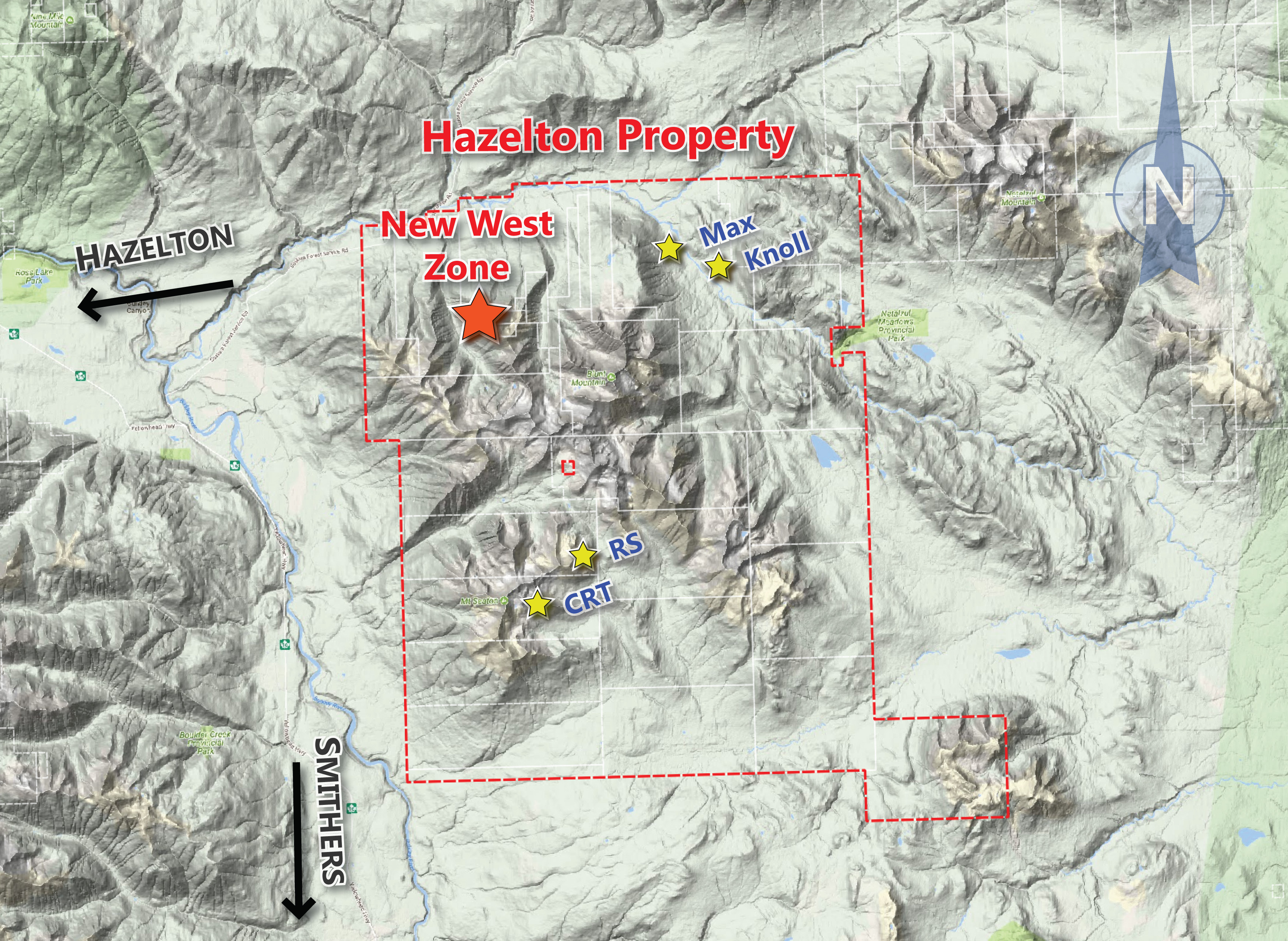
Max/Knoll
Click here for Max Project Update (June 29, 2020)
Highlights:
- 11 discrete intervals of high-grade silver (over 100g/t Ag) were intercepted in 7 of 12 holes drilled.
- These intercepts occur as antimony-rich silver sulphosalts in polymetallic veins, feeder breccias and stratiform beds, returning grades from 103 g/t to 1,206 g/t silver, up to 11.1% zinc and up to 2.07 g/t gold.
- The multiple-phase overprinting of polymetallic sulphide-sulphosalt mineralization is suggestive of a large and long-lived shallow-marine volcanogenic massive sulphide (VMS) system in this portion of the volcanic-sedimentary Rocky Ridge sequence.
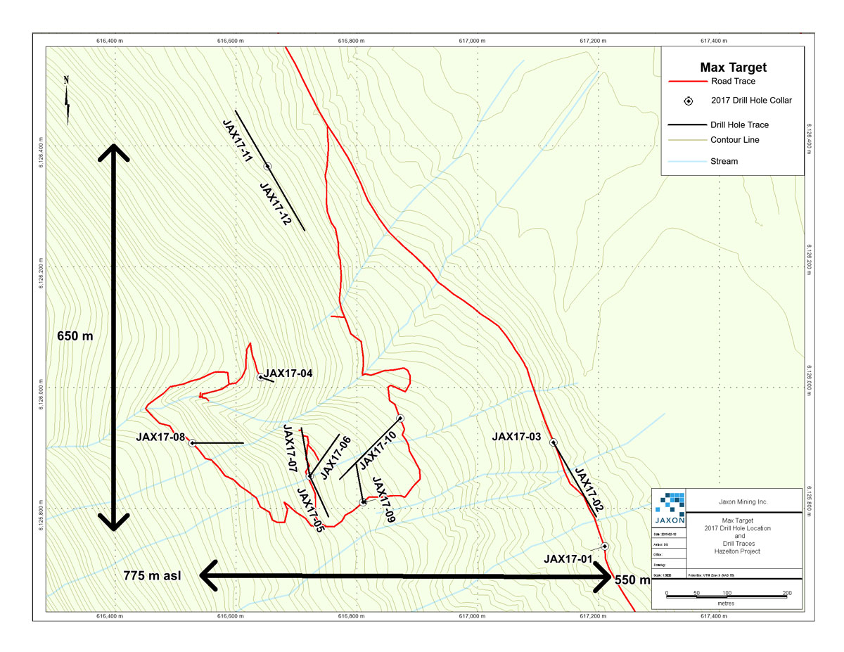
A total of 2,281 metres were drilled at the Max target in 12 holes, and 1,019 core samples were selected for assay. The drilling targeted modeled high chargeability and low resistivity locations from the ground-based 2D and 3D induced polarization (IP) survey. The 12 completed drill holes tested a roughly one-square kilometre area at the Max target along the northeastern slope of Blunt Mountain, from elevations of 550m to 775m, coincident with the channel sampling completed in the summer of 2017. This drill zone at Max only represents 0.2% of the area of the Hazelton Project, which covers a contiguous 47,000 hectares.
The Max target displays characteristics of the nearby Equity Silver Mine (once Canada's most profitable silver mine) including similar age rock, shallow marine setting, and possible remobilization of precious metal rich mineralization.
Polymetallic sulphides with variable presence of sulphosalts were found in rhyolite and tuffs, monzonite, and in marine sediments such as argillite and arenite. Variable quantities of semi-massive to massive stratiform-bedding parallel sulphides, cross cutting veins, and fractures have been found in all lithologies. It is evident that the IP survey responses tracked sulphides. No evidence of folding or major structural disruptions or faults was observed.
Due to the success of blind IP targeting, particularly in drill holes 17-11 and 17-12, Jaxon has made preliminary plans for an additional 1,000 – 4,000 metres of drilling at the Max zone in the coming 2018 field season. This drilling will also cover the area directly adjacent to the north of the known mineralized Max target, where a magnetic low (potentially due to hydrothermal alteration) is coincident with high chargeability targets. Jaxon's technical team and consultants continue to assess data from the 2017 field program and detailed plans for proposed work in 2018 at the Max target, as well as other highly prospective gold, silver and non-ferrous metals targets on the Hazelton Project, will be provided by separate press release.
Table of Significant Intercepts from 2017 Max Drilling of IP Survey, Hazelton | |||||||||||
Hole ID | Alt (m) | Depth (m) | from (m) | to (m) | Length (m) | Ag ppm | Sb % | Pb % | Zn % | Au ppm | |
JAX17-08 | 775 | 150 | 120.2 | 121.4 | 1.2 | 111 | 0.691 | 1.82 | 4.88 | 0 | |
JAX17-08 | 775 | 123.1 | 123.6 | 0.5 | 273 | 0.906 | 3.13 | 11.1 | 0 | ||
JAX17-04 | 725 | 129 | 37.9 | 38.3 | 0.4 | 15 | 0.268 | 0.64 | 7.78 | 0.268 | |
JAX17-07 | 700 | 192 | 76.5 | 78 | 1.5 | 103 | 0.282 | 0.53 | 3.08 | 0.01 | |
Jax17-05 | 700 | 129 | 85 | 86.1 | 1.1 | 13 | 0.258 | 0.62 | 2.97 | 0.166 | |
JAX17-06 | 700 | 144 | 95.2 | 96.2 | 1.0 | 114 | 0.509 | 0.73 | 5.27 | 0.003 | |
JAX17-09 | 675 | 108 | 30 | 31 | 1.0 | 109 | 0.256 | 0.53 | 4.16 | 0.257 | |
JAX17-10 | 625 | 201 | no high grade intercepts | ||||||||
JAX17-12 | 605 | 174 | 104.8 | 105.3 | 0.5 | 153 | 1.942 | 2.15 | 3.62 | 0.654 | |
JAX17-12 | 605 | 107.5 | 108.1 | 0.62 | 418 | 5 | 6.87 | 10.29 | 1.077 | ||
JAX17-11 | 605 | 150 | 92.33 | 92.53 | 0.2 | 1206 | 4.731 | 5.29 | 10.83 | 2.075 | |
JAX17-03 | 550 | 231 | 114.1 | 114.6 | 0.5 | 306 | 1.192 | 2.44 | 0.44 | 0.925 | |
JAX17-03 | 550 | 181.3 | 181.8 | 0.5 | 265 | 2.002 | 3.87 | 2.01 | 0.038 | ||
JAX17-03 | 550 | 192.2 | 192.8 | 0.6 | 146 | 1.316 | 1.51 | 1.23 | 0.085 | ||
JAX 17-02 | 550 | 201 | no high grade intercepts | ||||||||
JAX 17-01 | 550 | 171 | no high grade intercepts | ||||||||
2017 Max Target Drill Hole Location, Hazelton Project
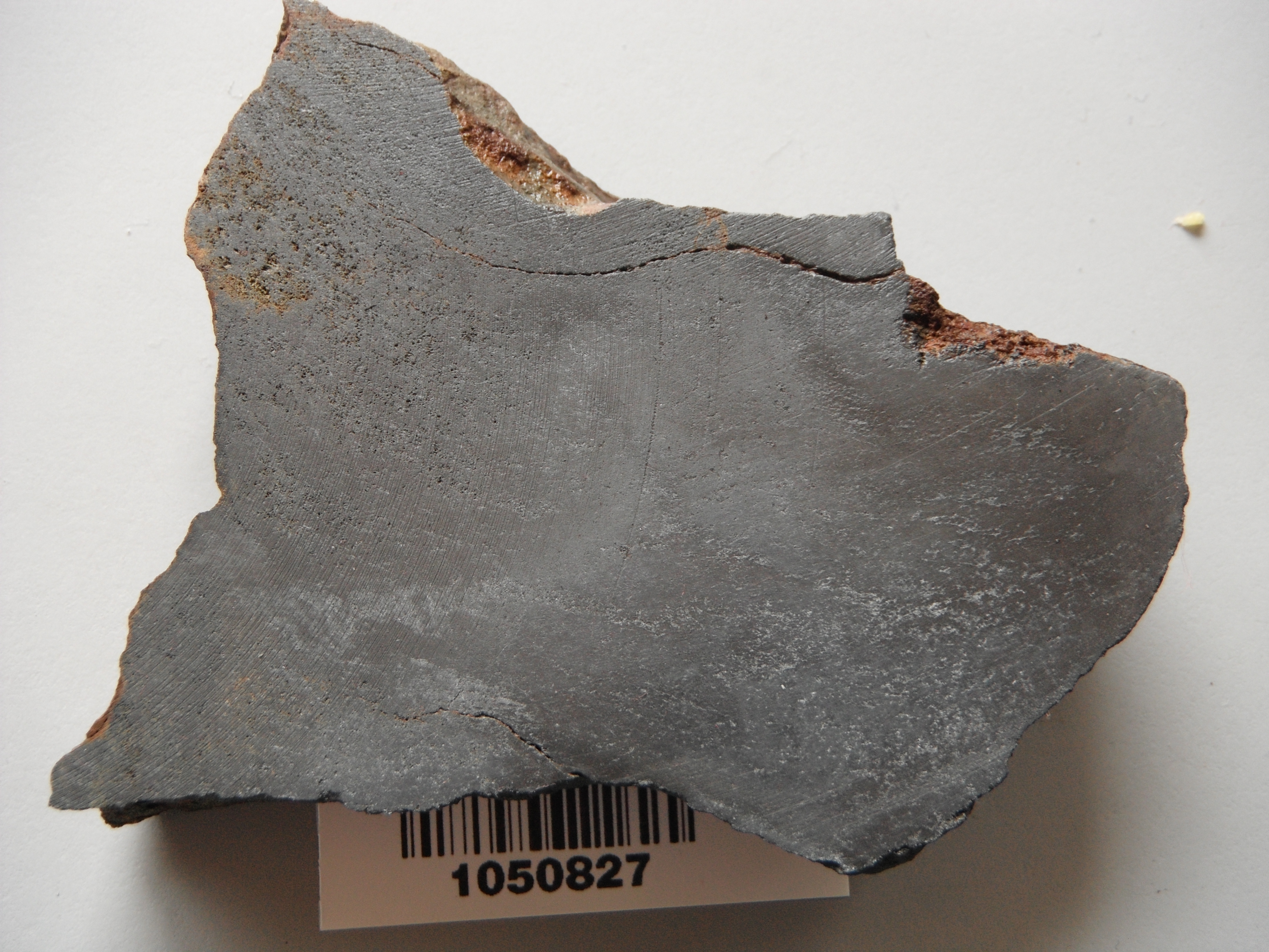
All core was transported daily to Jaxon's secure core logging/cutting facility in Smithers. The core was logged by a professional geologist and selectively sampled. The selected core sections were cut in half with one half placed back in the core box, and the other half prepared for shipment for analysis assay. The core sample lengths were generally one-metre displaying mineralized massive sulphide sections varying from 0.2m to 0.5m in length. All samples were packed in rice sacks, sealed, palettized, and securely shipped to MS Analytical Laboratories in Langley (ISO/IEC 17025:2005 certified), B.C. to undergo analysis.
The analyses included; ore grade poly metallics Code ICP-240 for Lead, Antimony, and Zinc in percent. Gold underwent 20g Aqua Regia ICP-AES-MS Code IMS-117, silver fire assay of a 30g Gravimetric Fusion Code FAS-418 was used to obtain the value of 1,206 g/t silver. Jaxon retains the remaining core samples in numbered core boxes stacked in a secure gated storage facility.
Jaxon conducted its own independent QA/QC program for the drill program inserting quality control samples - 1 in every 10 samples. This included the insertion of certified standards with 3 standards having silver contents in the high-grade range of the Max mineralized samples. Jaxon also inserted blanks and limited duplicate samples. These samples are checked to ensure results fall within acceptable target ranges and all results from the controls were acceptable.
Max Drilling Targets
The Phase 1, 2,000-metre drilling program is complete on the Max Target, on the north-eastern slope of Blunt Mountain. The program is targeting volcanogenic massive sulphide (VMS) occurrences, high chargeability and low resistivity (high conductivity) anomalies from the recently completed 2D and 3D IP survey coincident with highly mineralized channel, and soil assays. As reported on December 7, 2017, the company successfully drilled a total of 2,281 metres in 12 diamond drill holes, sending 1,019 samples to MS Analytical laboratory in Langley, BC. First assays are expected by late-December 2017. Core was sampled based on zones of mineralization, alteration and lithology and sampled intervals ranged in size from 0.5m to 2.0m, with the average being approximately 1.0m. Bruce Ballantyne, Jaxon's Project Manager, stated "At this stage, Jaxon has strong confidence that the zones of mineralisation noted in the drill core are directly related to the anomaly trends as modelled from the 3D and 2D IP survey." Representative samples of core from mineralized zones have been selected for future petrographic studies as well.
Observed Drilling Highlights
Preliminary observations of drill core provide strong evidence for a shallow marine VMS depositional environment. Notable features that support this include:
- Volcanic hosted sulphides (in rhyolite) and marine sediment argillite, arenite, wacke and tuff hosted sulphides have been observed and logged in all holes
- Zinc sulphides (sphalerite) have been intersected in fractures as cross-cutting veins, veinlets, stockworks, breccias, and at least one occurrence of stratiform-hosted mineralization
- Intersections of various widths of semi-massive to massive stratiform-bedding parallel sulphides, crosscutting veins - veinlets and fractures have been found in all lithologies
- The multiple phases - overprinting of polymetallic sulphide-sulphosalt mineralisation is suggestive of a potentially large and long-lived system in this portion of the volcanic-sedimentary Rocky Ridge sequence
Jaxon Drill Hole Map, Max Target, Hazelton Project
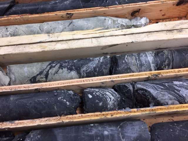
Jaxon Drill Core, Max Target, Hazelton Project
Complex contact between rhyolite (pale green-grey) and argillite. The contact relationships suggest either extrusion or intrusion of the rhyolite into still unconsolidated sediments.
Jaxon Drill Core, Max Target, Hazelton Project
Contact between rhyolite (green-grey)and argillite (black) grading into wacke (top compartment). The lower compartment shows porphyritic monzonite. This rapid variation of intrusive and sedimentary rocks is supportive of a very active sub-marine environment.
This model shows the results of Jaxon's 3D Induced Polarization geophysical survey over the Max Prospect. The green to yellow zones are areas of high chargeability in which the electrical properties of the material in these areas are such that a current introduced from the surface is able to "charge up" this material. Geologists interpret this attribute as being potentially indicative of sulphide mineralization. The blue areas represent areas of low electrical resistivity and similarly may represent areas of sulphide mineralization.
Jaxon has planned a diamond drilling program to test these prospective geophysical anomalies. The yellow lines are Jaxon's proposed drill holes. The white lines are the traces of historical drilling. As can be seen, almost all of these old drill holes failed to test the prospective geophysical anomalies. A few holes passed close to these anomalies and where they did so, encountered mineralization.
View our recent drone video here.
Max Zone
One of the main targets identified on the property is the Max Zone. The strata-bound VMS mineralization at the Max Zone has never been comprehensively sampled, and true extent of high-grade mineralization has, to date, remained unknown. The historical trenches at the Max Zone were excavated on a steeply-sloping hillside, exposing massive sulphides and associated alteration within a volcano-sedimentary package, over a lateral extent of 1,000 metres and a vertical extent of 450 metres.
The Max Zone will be one area targeted as part of the 2017 exploration work.
Mineralization at the Max Zone occurs over a lateral extent of approximately 1,220 metres and largely consists of stratabound massive sulphide mineralization. At 1,000m elevation, the Spine showing is the highest elevation outcrop on the property. The Spine showing nearby also returned one of the highest gold assays, at 12.7 g/t Au.
Jaxon has compiled historical results with exceptional grades over 1,220 metres of recurrent surface exposure at the Max Zone, representing more than 450 metres of elevation change. The current field program will add substantial new information to this data, as Jaxon continues to explore its Hazelton Project.
High Grade Rock Chip Surface Samples from Max Zone
| Ag Equ g/t | Ag g/t | Au g/t | Pb % | Zn % |
| 4,403.2 | 3,398 | 2.3 | 15.1 | 11.9 |
| 2,053.1 | 469 | 0.6 | 39.5 | 9.8 |
| 1,767.5 | 481 | 3.4 | 27.2 | 6.4 |
| 1,744.9 | 1231 | 0.4 | 5.8 | 9.6 |
| 1,722.5 | 480 | 2.9 | 26.8 | 6.5 |
| 1,453.7 | 353 | 2.0 | 30.6 | 0.5 |
| 1,404.0 | 419 | 2.6 | 14.0 | 11.6 |
Ag Equ based on: US$18.2/oz silver, US$1,240/oz gold, US$0.91/lbs lead and US$0.94/lbs zinc.
New Discoveries
Hazelton map showing discoveries announced Sep 14 and Sep 25.
On June 15, 2017, the Company announced two new discoveries as a result of its Phase I exploration program.
Sampling and New Discovery at Trench 742 South
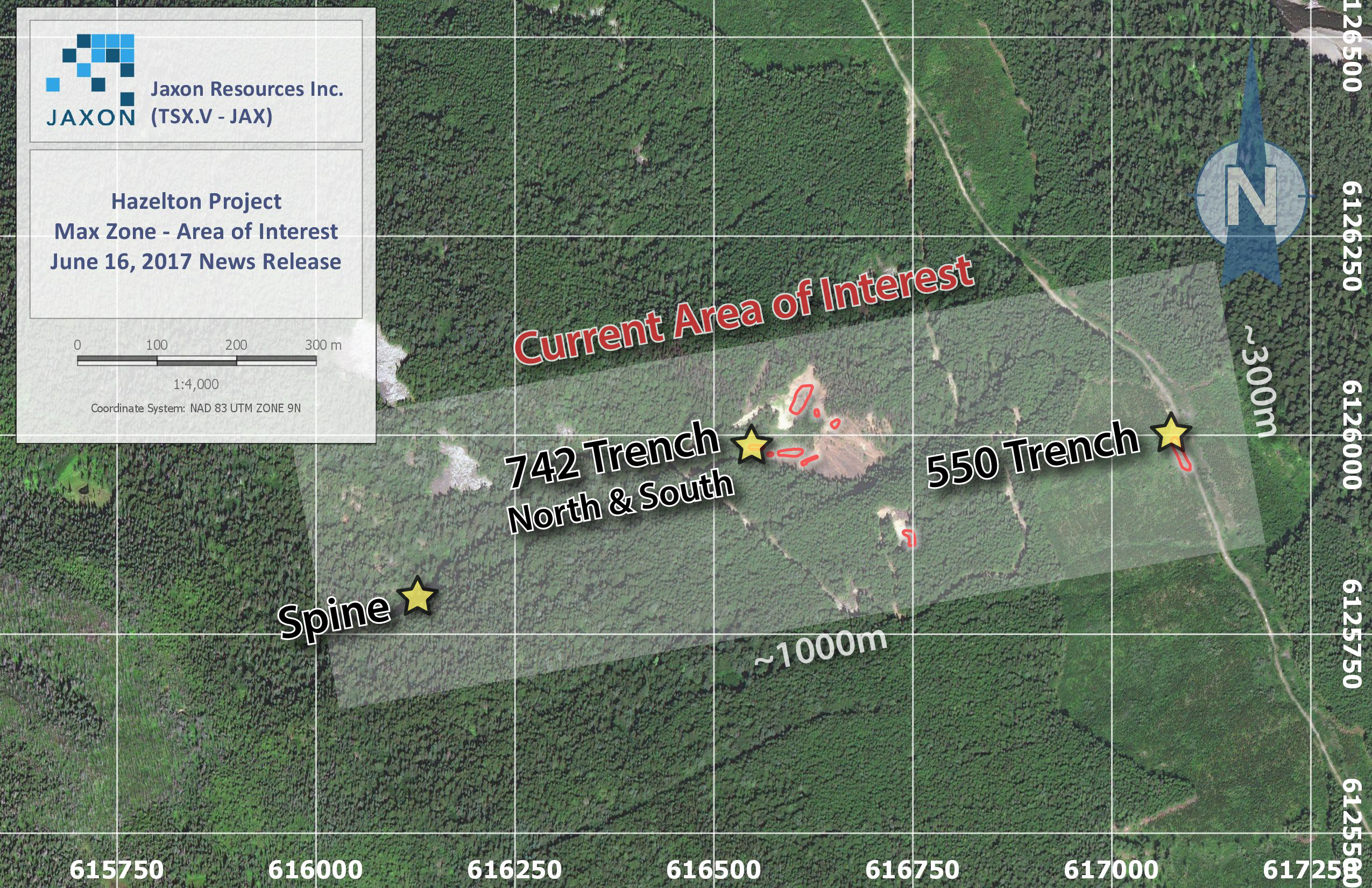
Sampling work has been focused on Trench 742 South, which yielded historical values of up to 2,171 g/t Ag, 3.89 g/t Au, 18.8% Zn, and 39.5% Pb in grab samples, as previously reported. Rehabilitation and new channel sampling at two locations (7 and 6 metre channels, respectively) across the historical trench has revealed a massive sulphide unit overlain by a massive silver sulphosalt bed which has never been sampled continuously over its entire width.
Approximately 30 metres north and up-slope from Trench 742 South, the exploration team discovered a new, similar, silver sulphosalt lens showing, named Occurrence 742 North. This discovery has been expanded and trenched to expose a 30-metre high rock wall showing multiple, previously unidentified lenses and beds of silver sulphosalts hosted by a marine volcano-sedimentary sequence.
New Discovery near 550 Trench
The 550 Trench, which yielded historical values of 937 g/t Ag, 2.78 g/t Au, 4.31% Zn, and 3.83% Pb, was previously identified as float adjacent to a well-maintained trail. The in-situ source of the 550 Trench has now been discovered in a 5-metre wide rock wall exposure comprising a silver sulphosalt and gold-bearing massive sulphide vein or unit. The exposure will be continuously channel sampled in the coming weeks.
Along a trail extending from the 550 Occurrence, the team also conducted geological mapping over 1.5 kilometres to the south-southeast of the known mineralization at the Max Zone.
Early Exploration
In May (see press releases dated May 30, 2017 and June 7, 2017), the Company announced that field crews and staff members had been mobilized to the property in order to begin the first phase of its 2017 exploration program. This field program is designed to systematically follow up data generated by previous operators, including 2,800 soil samples, 174 saw-cut 1-metre channel samples, and recently-acquired data from a 464 line-kilometre magnetic and resistivity airborne VTEM survey. Results from the field program, including structural analysis, have been used to better understand the setting and extent of bonanza grades of precious and base metals, with grab samples from historical trenching and float reaching assay values up to 3k g/t silver and over 20% lead and zinc samples, found over 450m of vertical extent and a roughly 1 square kilometre surface extent.
Jaxon has identified high priority targets, which has been subject to systematic and continuous trench sampling, including areas of semi-massive to massive banded and bedded high-grade sulphides. This has provided averaged grade contents over significant widths and along strike. A focused gradient induced polarization (IP) survey has been used to further define the depth and extent of these structures prior to drilling.
Elsewhere within the VTEM survey area, field crews have used data to identify new targets. These targets have been prospected and trenched, as have the widespread multi-element anomalous soil targets identified within the 3 kilometre by 1 kilometre detailed survey grid.
A regionally focused team has conducted prospecting, mapping and stream water and sediment sampling for exploration as well as environmental baseline monitoring. This team is targeting BC Department of Mines regional geochemical survey anomalies and their respective drainage basins for further detailed systematic examination.